Categories : Medium Tracks (27)
Tracks
-
8.18k
Centre: Agua de Bueyes – Vega de Rio Palmas – SL FV 28.
- Distance: 6060.99 m.
- in Medium Tracks
- 10 years ago.
- 8175 hits
The track is running through one of the most productive agricultural areas of the island and comes close to the reforestation project.Approx: Distance: 6 km – Approx. Elevation: 270 m -
7.91k
Centre: Antigua – Degollada de Marrubio – Betancuria – SL FV 29.
- Distance: 5569.55 m.
- in Medium Tracks
- 10 years ago.
- 7905 hits
The track crosses the Betancuria mountain range. From the top you will enjoy the surrounding landscapes which are one of the oldest formations of the island.Approx: Distance: 5,6 km – Approx. Elevation: 340 m Google(R) Fly-Over -
14.1k
Centre: Betancuria – Mta. Morro de la Cruz.
- Featured
- Distance: 6741.63 m.
- in Medium Tracks
- 10 years ago.
- 14149 hits
The track starts on an asphalted road that you will leave soon for a dirt track. You will walk on a schoulder with superb views on the valley and finally get to the top with astonishing views over the central area of Fuerteventura. On the way back you will pass the statues of the two... -
9.24k
Centre: Tiscamanita – Caldera de Arrabales
- Distance: 8915.45 m.
- in Medium Tracks
- 10 years ago.
- 9240 hits
The track passes through the central plains of Fuerteventura and is the ancient road that the locals used to get to the East coast. A part of the track goes through the "Malpais Grande", a lava river which once flowed till Pozo Negro.Approx: Distance: 9 km – Approx. Elevation: 148... -
6.69k
Centre: Tiscamanita – Mta. Morro Jorjado.
- Distance: 4099.61 m.
- in Medium Tracks
- 10 years ago.
- 6685 hits
You can start your walk from the village or from the beginning of the dirt track. The ascend starts slow, but increases rapidly. You will cross some dry river beds (Barrancos) to reach the top with nice views over the central area of Fuerteventura. Approx. distance: 4,1 km, approx. elevation: 417 m -
7.88k
Centre: Tiscamanita – Vega de Rio Palmas – SL FV 31
- Distance: 8192.84 m.
- in Medium Tracks
- 10 years ago.
- 7878 hits
The track crosses the Betancuria mountain range which has been altered a long time ago by humans to accommodate for agriculture. Now abandoned, they remain silent witnesses of ancient activity. Approx: Distance: 8,2 km – Approx. Elevation: 420... -
6.57k
Centre: Tuineje - Tiscamanita (SL FV 09).
- Distance: 6080.19 m.
- in Medium Tracks
- 10 years ago.
- 6573 hits
The track passes the old agricultural area of the island and you can enjoy some old architecture. The volcano La Gairia is almost omnipresent during this walk. Approx: Distance: 6 km – Approx. Elevation: 109 m -
6.68k
Centre: Valles de Ortega - Betancuria (SL FV 10).
- Distance: 9309.07 m.
- in Medium Tracks
- 10 years ago.
- 6677 hits
The track will bring you close to the highest mountain of the area and will pass next to a re-forestation project before you will reach the first capital of the island.Approx: Distance: 9,3 km – Approx. Elevation: 460 m -
16.4k
North: Corralejo - Calderon Hondo - Lajares (GR131)
- Featured
- Distance: 10300.35 m.
- in Medium Tracks
- 10 years ago.
- 16354 hits
The track starts with a light slope towards a platform with nice views over Lajares, Villaverde and the distant dunes. The short climb (approx. 100m) to the summit of the volcano is somewhat heavy, especially when it is hot, but is also doable for kids over 12. From here you have a... -
13.3k
North: Corralejo – Mta. Bayuyo.
- Distance: 2947.92 m.
- in Medium Tracks
- 10 years ago.
- 13320 hits
You can climb this volcano from 2 sides: West or East or make a round trip. The track has some steep parts and on the top you can overview Corralejo, Lobos, the North-West coast and Lanzarote.Approx: Distance: 3 km – Approx. Elevation: 180... -
8.56k
North: La Matilla – Mta. La Muda
- Featured
- Distance: 1542.41 m.
- in Medium Tracks
- 10 years ago.
- 8557 hits
The track has several short steep climbs, you pass ancient wells and at the end you will enjoy a breathtaking view over Mta. Tindaya and the West coast.Approx: Distance: 1,5 km – Approx. Elevation: 215 m Google(R) Fly-Over -
10.6k
North: Lajares – Barranco Cho Cruz – Del Diable
- Distance: 6751.56 m.
- in Medium Tracks
- 10 years ago.
- 10612 hits
The track guides you through small sandy canyons and over volcanic hills till a nice view point from where you can overlook the west coast and El Cotillo. An ideal place to watch sunset, but don't stay too long afterwards as you will need sufficient light to return.Approx. distance:... -
8.03k
North: Lajares – Cañada de Melián – El Cotillo
- Distance: 8034.08 m.
- in Medium Tracks
- 10 years ago.
- 8031 hits
The track will bring you in quiet surroundings, specific nature, nice views towards the West coast and to an ancient defensive tower.Approx: Distance: 8 km – Approx. Elevation: 138 m Google(R) Fly-Over -
7.58k
North: Tetir – Casillas de Angel
- Distance: 6923.3 m.
- in Medium Tracks
- 10 years ago.
- 7575 hits
The track has a lot of climbing and you will see interesting geologic formations. From the top you can see the ancient cereal cultivation grounds.Approx: Distance: 6,9 km – Approx. Elevation: 250 m Google(R) Fly-Over -
7.78k
North: Tetir – Degollada de Facay - Tefía
- Distance: 7791.84 m.
- in Medium Tracks
- 10 years ago.
- 7782 hits
The track runs trough a gorgeous valley with a lot of geologic formations, created by erosion. You can also find many endemic plants. Approx: Distance: 7,8 km – Approx. Elevation: 240 m Google(R) Fly-Over -
7.52k
North: Tindaya – Vallebrón – La Matilla – PR FV 09
- Distance: 9967.65 m.
- in Medium Tracks
- 10 years ago.
- 7522 hits
The track is passing a lot of rural area and will show you some info about the ancient rural activity that was heavily connected to the harsh nature. Approx: Distance: 10 km – Approx. Elevation: 300 m Google(R) Fly-Over -
8.62k
North: Villaverde – Mta. Escanfraga (1)
- Distance: 1475.36 m.
- in Medium Tracks
- 10 years ago.
- 8622 hits
The track will bring you almost to the top from where you can enjoy a superb view over the North of Fuerteventura.Approx: Distance: 1,5 km – Approx. Elevation: 160 m Google(R) Fly-Over > -
8.26k
North: Villaverde – Mta. Escanfraga (2)
- Distance: 1889.67 m.
- in Medium Tracks
- 10 years ago.
- 8264 hits
The track will bring you almost to the top from where you can enjoy a superb view over the North of Fuerteventura.Approx: Distance: 1,9 km – Approx. Elevation: 54 m Google(R) Fly-Over -
8.31k
South: Cardón – Mount Cardón – SL FV 53
- Distance: 2369.9 m.
- in Medium Tracks
- 10 years ago.
- 8307 hits
The track climbs steeply on the mountain Cardón, one of the most emblematic natural elements of Fuerteventura. From the end point one has a magnificent view over the West coast and the plains of Fuerteventura. Approx: Distance: 2,3 km – Approx. Elevation: 200 m -
10.5k
South: Cofete – Morro Jable.
- Distance: 5809.62 m.
- in Medium Tracks
- 10 years ago.
- 10498 hits
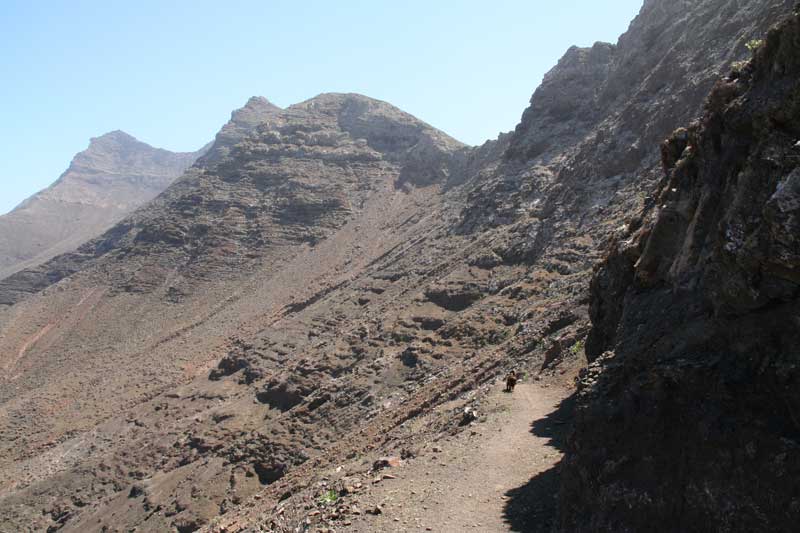
The track starts at the east entrance of Cofete and goes relatively flat for a while. After about 2km you will begin a steep climb to the shoulder of the pass. Here – halfway – you can rest and enjoy the marvellous views back to Cofete or to the valley going to Morro Jable. The second part... -
12.4k
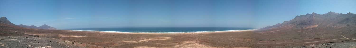
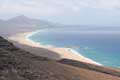
South: Costa Calma – West Coast 1.
- Distance: 3367.76 m.
- in Medium Tracks
- 10 years ago.
- 12423 hits
This track crosses the narrowest part of the island from East to West and runs through a sandy area. You get a good impression about the differences in power of the waves between East and West.Approx: Distance: 3,3 km – Approx. Elevation: 52 m Google(R)... -
8.63k
South: Jandia – Barranco de Pecenescal.
- Distance: 5049.72 m.
- in Medium Tracks
- 9 years ago.
- 8631 hits
The track, which starts at the FV02 secondary road from Jandía to Costa Calma, will bring you to a famous view point which overlooks the impressive Barlovento coast line. The track is a mix of sandy and rocky road. Approx: Distance: 5 km – Approx. Elevation: 204... -
7.24k
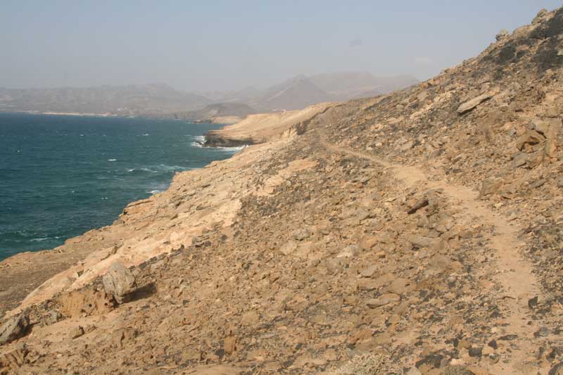
South: La Pared - Risco del Paso (GR131)
- Distance: 10976.34 m.
- in Medium Tracks
- 10 years ago.
- 7242 hits
A sandy hiking track, starting from La Pared to Risco del Paso near Costa Calma. A part of this track is the shortest distance to cross the island from one side to the other. Approx. distance: 11 km - approx. elevation: 130 m Google(R) Fly-Over -
9.88k
South: La Pared – Rincón del Camello
- Distance: 4297.81 m.
- in Medium Tracks
- 10 years ago.
- 9880 hits
Attention: steep slopes, we strongly disadvise to walk this track with children or with people who have fear of height.The track leads you to a barranco (gorge) that ends on very special shapes of sand, carved by the elements water and wind. Further you will come to a Caldera (mouth of a... -
8.48k
South: Mal Nombre – Morro de la Burra
- Distance: 11295.81 m.
- in Medium Tracks
- 10 years ago.
- 8479 hits
This track is also possible for bikes and even normal cars as it is completely asphalted, although there are some bad spots. You pass along a wide valley till the shoulder of the hill. The view here is absolutely spectacular and should strongly be recommended to all those who... -
6.73k
South: Morro Jable - Playa de la Barca (GR131)
- Distance: 12379.36 m.
- in Medium Tracks
- 10 years ago.
- 6733 hits
A medium walk from Morro Jable to Playa de la Barca. Most of the time you will be walking along the shore. Approx. distance: 12 km - approx. elevation: -70 m (downhill) -
12.9k
South: Morro Jable – Cofete – PR FV 55
- Featured
- Distance: 5809.62 m.
- in Medium Tracks
- 10 years ago.
- 12875 hits
The track goes relatively flat for a while. After about 2km you will begin a steep climb to the shoulder of the pass. Here – halfway – you can rest and enjoy the marvellous views to Cofete and the villa Winter.Approx. distance: 5,8 km / Approx. elevation: 280...


 The track crosses the Betancuria mountain range. From the top you will enjoy the surrounding landscapes which are one of the oldest formations of the island.
 The track starts at the east entrance of Cofete and goes relatively flat for a while. After about 2km you will begin a steep climb to the shoulder of the pass. Here – halfway – you can rest and enjoy the marvellous views back to Cofete or to the valley going to Morro Jable. The second part of the descent can be hot.


 You can climb this volcano from 2 sides: West or East or make a round trip. The track has some steep parts and on the top you can overview Corralejo, Lobos, the North-West coast and Lanzarote.

.jpg) This track crosses the narrowest part of the island from East to West and runs through a sandy area. You get a good impression about the differences in power of the waves between East and West.
This track crosses the narrowest part of the island from East to West and runs through a sandy area. You get a good impression about the differences in power of the waves between East and West..jpg) The track has several short steep climbs, you pass ancient wells and at the end you will enjoy a breathtaking view over Mta. Tindaya and the West coast.
The track has several short steep climbs, you pass ancient wells and at the end you will enjoy a breathtaking view over Mta. Tindaya and the West coast.


.jpg)
.jpg)
.jpg)
 The track, which starts at the FV02 secondary road from Jandía to Costa Calma, will bring you to a famous view point which overlooks the impressive Barlovento coast line. The track is a mix of sandy and rocky road.